


l'espignon ,ruine Spaeny, villa Teychene, sémaphore

ego
User
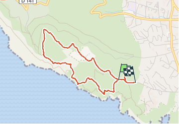

Length
4.1 km

Max alt
278 m

Uphill gradient
226 m
Km-Effort
7.2 km

Min alt
48 m

Downhill gradient
237 m
Boucle
No
Creation date :
2022-04-09 12:20:33.013
Updated on :
2022-05-06 06:46:05.643
4h46
Difficulty : Medium

FREE GPS app for hiking
 SityTrail
IGN / Geographical institutes
SityTrail Plus
The world is yours!
About
Trail Walking of 4.1 km to be discovered at Provence-Alpes-Côte d'Azur, Bouches-du-Rhône, La Ciotat. This trail is proposed by ego .
Description
montée par la colline et les 3 ruines,retour par le PR
JAUNE (chemin de la Vigie)
Photos

Positioning
Country:
France
Region :
Provence-Alpes-Côte d'Azur
Department/Province :
Bouches-du-Rhône
Municipality :
La Ciotat
Location:
Unknown
Start:(Dec)
Start:(UTM)
710409 ; 4783076 (31T) N.
Comments